 |
| NPHS 1510: Federal and International |
| Geographic Information Systems (GIS) |
|
| |
| Preparation |
| |
In order to get the most out the geographic material that we will give you, you will need to acquire, install and learn to use ArcGIS from ESRI, Inc. ArcGIS is the most widely used GIS product in the world. This lesson assumes that you will be taking the lesson while simultaneously running ArcGIS.
The preparatory process involves several simple steps:
- Visit the Pitt Technology web site - http://technology.pitt.edu/
- Navigate to the ArcGIS page - > Software & Hardware > For Students > ArcGIS - http://technology.pitt.edu/software/for-students-software/arceditor-st.html
- Note that you can buy ArcInfo 10.0 and Data & Maps and StreetMap USA Extension for $5.00 each
- Pat yourself on the back because this software would cost well over $1000 commercially
- Visit Software Licensing Services (SLS) in 204 Bellefield Hall (MAP) between the hours of 8:30 am - 5:00 pm Monday through Friday (closed University holidays).
- Remember to take your Pitt ID and cash, check, MasterCard, Visa, or Panther Funds. Sales tax will be added to the price.
- Install the software on the DVDs on your computer
- Visit the ESRI web site - http://www.esri.com
- On the ESRI web site familiarize youself with:
- Tutorials/Training
- Help
- Data for download
- Support
|
| |
| Installation Test |
| |
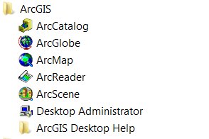
| To see if your installation has been successful, click on the Windows Start Menu Icon and expant the All Programs Section. Navigate to the ArcGIS folder icon and expand it. Your should get a display that looks like: |
| |
 |
| |
| As you can see, many programs came with your purchase. For this course and lesson we are going to focus on ArcMap. The student is left to his or her own initiative to avail him or herself of the wonderful learning opportunity represented by the other ArcGIS programs. |
| |
| Click on the ArcMap icon and open the program. You should get the ArcMap interface which is depicted below. |
| |
 |
| |
|
|
|
|
| Copyright © 2011 Ken Sochats |


